Services
High Performance Detections
MObile MApping System
Vehicle for the acquisition of data necessary for road classification and the creation of the road cadastre.
AISICO has an innovative vehicle for High Performance Surveys of road characteristics.
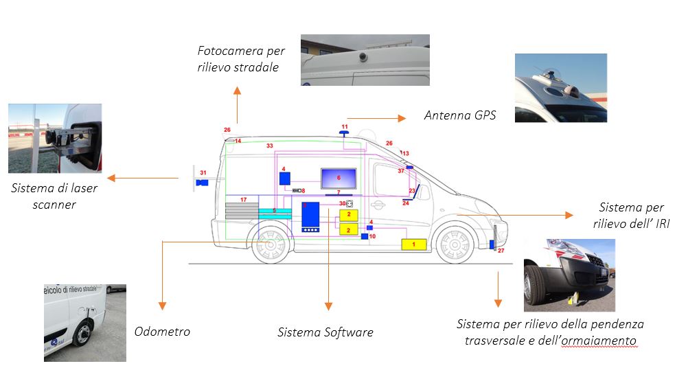
The vehicle, called MO.MA.S., Mobile Mapping System, was totally designed and built by Aisico’s R&D department and is equipped with the most modern equipment for road surveying: it allows high-performance acquisition of the information needed for timely knowledge of the infrastructure.
The vehicle is equipped with high-definition cameras, IMU inertial control unit with GPS and odometer, lasers for pavement characteristics and road geometry, sound level meters for surveying pavement noise, and special cameras for surveying vertical signs. All information can be uploaded to proprietary software with which integrated infrastructure management is possible. The MO.MA.S. vehicle enables high-performance detection of all the information necessary for the creation of the road cadastre in accordance with Ministerial Decree 3484 of 01/06/2001.
MO.MA.S. is able to acquire:
- Road layout with associated appurtenances;
- 360° georeferenced video of the road;
- Survey of IRI – International Roughness Index – for longitudinal evenness of pavements;
- Survey of the MPD – Mean Profile Depth – for macro texture of pavements;
- Survey of CPX – Close Proximity Method – for acoustic characteristics of pavements;
- Video and laser survey of pavement surface conditions (cracks and footprints);
- Pavement planimetric characteristics (transverse and longitudinal slope);
- Survey with LIDAR technology of geometric characteristics of embankments, including measurement of embankment width and height;
- Survey of the retroreflectivity of vertical signs through the VERTRAS – Vertical Traffic Road Signal system;
- Survey of geometric and defectological characteristics of tunnels.
Video cameras
Video cameras in an “all around” configuration that acquire information simultaneously; of these, the lateral ones allow survey of the section orthogonal to the direction of travel.
Laser Scanner
A system of laser scanners that, through the technique of laser ranging and infrared, are able to provide additional information compared to traditional imaging techniques, allowing a more accurate analysis of roadway encumbrances and tunnel profile.
Profilometer Bars
Longitudinal profilometer bar capable of detecting IRI (International Roughness Index) and MPD (Mean Profile Depth), the index of pavement roughness and macrotexture, respectively. The system is mounted inside the bumper of the vehicle to protect it from impacts and weathering while moving. A novel element are the two independent inertial profilometers placed in axis with the front wheels of the vehicle, which can optimize the profile surveying process.
The transverse profilometer bar for transverse slope and heave measurement is equipped with seven high-performance lasers capable of covering a total range of 180 cm.
GPS, odometer and data acquisition and processing systems
GPS unit to ensure geolocation of data acquired during the survey. The vehicle can also be equipped with odometer and additional data acquisition and processing systems.
The integrated system is managed by two automotive PCs installed in the rear compartment of the vehicle that the operator accesses from the cabin station during the survey campaign. The various servers, synchronized with each other via the GPS receiver, ensure synchronous management of the data flow of all instruments and data storage. The survey campaign is managed from the control dashboard capable of displaying all survey systems in use on a single screen.
The system is of course upgradable and can be integrated with other instrumentation as required.